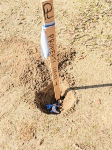
The purpose of a boundary survey (property line survey) is to establish the boundary of a property on the ground using record information (deeds, maps, etc.). This typically involves locating, and setting or restoring property corners (i.e. monuments). Monuments typically consist of iron rebar or iron pipes driven into the ground 2 feet or more. Regardless of what is set in the ground, the monument will have a cap or tag indicating the surveyor’s license number as required by state law.
Boundary surveys are generally necessary for:
- Building or other improvements planned to be located on or near either the property line or property setback line.
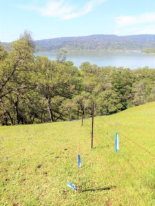
- Constructing a new fence or replacing one on the property line.
- Buying or selling a property where the property lines are unclear.
- To resolve a dispute neighbors may have regarding the location of the property line.
- Locating easements in favor of or burdening the property.
- Subdividing a property.
Boundary surveys fall into three categories:
- Locating boundary corners and lines shown on a Record of Survey Map, Parcel Map, Subdivision Map or other Record Map:
- These properties have had a boundary survey performed prior or were created with a recorded map.
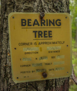
- When conducting this type of boundary survey, a surveyor must collect sufficient evidence of original monuments (iron pipes, rebar, wood stakes, brass monuments etc.) that were set/found at the time of the survey. The surveyor must also verify the monument positions compared with what the Record Map shows. If the monuments match with the record, the surveyor can then flag the corners and mark the lines and the survey is complete.
- This type of boundary survey is the least expensive and varies in cost depending on the size of the property and the terrain where the property is located.
- If any property corners are missing or discrepancies exist from what the record map shows, then a Corner Record Map or Record of Survey Map may be required to be filed (see Options 2 & 3 below).
- Restoring missing property corners shown on a Record of Survey Map, Parcel Map, Subdivision Map or other Record Map (Corner Record Map):
- These properties are missing some or all of their property corners, have had a boundary survey performed prior, and the boundary lines have been shown on a recorded map.
- When conducting this type of boundary survey, a surveyor must collect sufficient evidence of original monuments (iron pipes, rebar, wood stakes, brass monuments etc.) that were set/found at the time of the survey. If the evidence collected matches with the Record Map, the surveyor can then restore any of the missing boundary corners at their record positions. The surveyor is then required by state law to create and file a boundary survey map called a "Corner Record Map".
- This type of boundary survey is slightly more expensive than Option 1 listed above due to the time it takes to create and file the Corner Record Map with the respective county.
- If any discrepancies exist from what the Record Map shows, then a Record of Survey Map may be required (see Option 3 below).
- Establishing property corners for a parcel that has not had its boundary surveyed, or resolving discrepancies found between the evidence collected and the record information (Record of Survey Map):
- These properties have never had a boundary survey performed, or there is a substantial discrepancy between what the previous record information shows versus the information and evidence the land surveyor collected at the time of the recent survey.
- When conducting this type of boundary survey, a surveyor must complete extensive title research (trace the history of the deeds back to the properties creation) on the subject property and the neighboring properties. The surveyor then must search for and collect boundary evidence pertinent to the records he/she researched. After this, the surveyor must evaluate the evidence collected versus the record information and determine how to resolve the boundary of the property. If the subject property was part of a sequential conveyance, the property may receive all or a portion of what the records indicated depending on if it had senior or junior rights over the surrounding properties. If the subject property was part of a simultaneous conveyance, any excess or deficiency found is distributed to the properties involved in the conveyance equally.
- Once the boundary of the property has been resolved, a surveyor must create a “Record of Survey Map” showing all the evidence collected and how he/she resolved the boundary. This map is then filed with the respective county where the property is located in. The surveyor then sets the property corner monuments and can stake the property lines. Every County requires a map review fee and recording fee be paid. These can cost between $400- $1000 depending on the specific county.
- This type of boundary survey is the most expensive and varies in cost, depending on the specific county the property is located within, what the type of terrain is (mountainous, flat etc.), the size of the property, and the record survey information available near the property.
Important note regarding boundary surveys in California:
California State Law requires Land Surveyors to file a map with the County upon completion of the boundary survey where they set the property corners. This document may be a Corner Record map, or a Record of Survey map, depending on which situation listed above the property falls into.
It is extremely important that you receive a copy of the map to be recorded from your surveyor. If your surveyor sets monuments on your property without filing a map, he/or she is breaking the law. Although you may get your property corners set at a reduced price, that survey may not be recognized in the future by other surveyors since the survey was not properly recorded. Having the surveyor record a map is your guarantee that he/she is standing behind their work. A boundary survey that is not properly documented in accordance with state law is really not worth any fee!